Tipper
This object can be used to store tipper (ZTEM) surveys - a natural-source geophysical method. Data are provided in the frequency-domain as point source measurements of tipper data.
The following example shows how to generate a tipper survey with associated data stored in geoh5 format and accessible from Geoscience ANALYST.
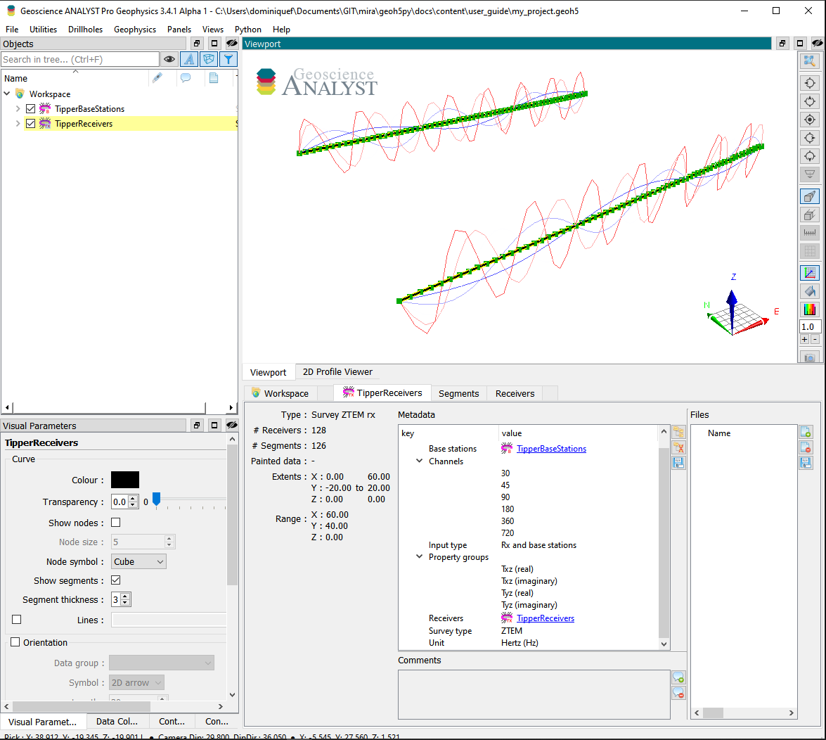
[1]:
import numpy as np
from geoh5py.workspace import Workspace
from geoh5py.objects import TipperReceivers, TipperBaseStations

# Create a new project
workspace = Workspace("my_project.geoh5")

# Define the pole locations
n_stations = 64
n_lines = 2
x_loc, y_loc = np.meshgrid(np.linspace(0, 60, n_stations), np.linspace(-20, 20., n_lines))
vertices = np.c_[x_loc.ravel(), y_loc.ravel(), np.zeros_like(x_loc).ravel()]

# Assign a line ID to the poles (vertices)
parts = np.kron(np.arange(n_lines), np.ones(n_stations)).astype('int')

# Create the survey from vertices
receivers = TipperReceivers.create(workspace, vertices=vertices, parts=parts)
base = TipperBaseStations.create(workspace, vertices=vertices)
We have so far created two seperate entities, one for the receiver locations and another for the base station(s). In order to finalize the survey, the association must be made between the two entities:
[2]:
receivers.base_station = base
or equivalently
[3]:
base.receivers = receivers
Only one of the two options above is needed.
Metadata
Along with the TipperReceivers, the metadata contains all the necessary information to define the geophysical experiment.
[4]:
receivers.metadata
[4]:
{'EM Dataset': {'Base stations': UUID('973a49b8-0785-45de-9404-25c8319bae33'),
  'Channels': [],
  'Input type': 'Rx and base stations',
  'Property groups': [],
  'Receivers': UUID('f228a1e6-d745-4207-906a-5a5688761eb8'),
  'Survey type': 'ZTEM',
  'Unit': 'Hertz (Hz)'}}
Channels
List of frequencies at which the data are provided.
[5]:
receivers.channels = [30., 45., 90., 180., 360., 720.]
Input type
Generic label used in the geoh5 standard for all EM survey entities. Restricted to Rx and base station in the case of a tipper survey.
Property groups
List of PropertyGroups defining the various data components (e.g. Txz (real), Tyz (imag), …). It is not required to supply all components of the impedence tensor, but it is expected that each component contains a list of data channels of length and in the same order as the Channels (one Data per frequency).
The class method add_components_data can help users add data from nested dictionaries. Below is an example using four components:
[6]:
# Arbitrary data generator using sine functions
data_fun = lambda c, f: (c+1.) * (f+1.) * np.sin(f * np.pi * (x_loc * y_loc).ravel() / 400.)

# Create a nested dictionary of component and frequency data.
data = {
    component : {
        f"{component}_{freq}": {"values": data_fun(cc, ff)} for ff, freq in enumerate(receivers.channels)
    } for cc, component in enumerate([
        "Txz (real)", "Txz (imaginary)",
        "Tyz (real)", "Tyz (imaginary)",
    ])
}

receivers.add_components_data(data)
[6]:
[<geoh5py.groups.property_group.PropertyGroup at 0x7fd2d6542740>,
 <geoh5py.groups.property_group.PropertyGroup at 0x7fd2d6543070>,
 <geoh5py.groups.property_group.PropertyGroup at 0x7fd2d65c4250>,
 <geoh5py.groups.property_group.PropertyGroup at 0x7fd3001f13c0>]
Metadata are updated immediately to reflect the addition of components:
[7]:
receivers.metadata
[7]:
{'EM Dataset': {'Base stations': UUID('973a49b8-0785-45de-9404-25c8319bae33'),
  'Channels': [30.0, 45.0, 90.0, 180.0, 360.0, 720.0],
  'Input type': 'Rx and base stations',
  'Property groups': ['Txz (real)',
   'Txz (imaginary)',
   'Tyz (real)',
   'Tyz (imaginary)'],
  'Receivers': UUID('f228a1e6-d745-4207-906a-5a5688761eb8'),
  'Survey type': 'ZTEM',
  'Unit': 'Hertz (Hz)'}}
Data channels associated with each component can be quickly accessed through the BaseEMSurvey.components property:
[8]:
receivers.components
[8]:
{'Txz (real)': [<geoh5py.data.float_data.FloatData at 0x7fd3001c34c0>,
  <geoh5py.data.float_data.FloatData at 0x7fd2d68cd540>,
  <geoh5py.data.float_data.FloatData at 0x7fd3001c1ba0>,
  <geoh5py.data.float_data.FloatData at 0x7fd3001c24a0>,
  <geoh5py.data.float_data.FloatData at 0x7fd2d65423e0>,
  <geoh5py.data.float_data.FloatData at 0x7fd2d65427a0>],
 'Txz (imaginary)': [<geoh5py.data.float_data.FloatData at 0x7fd2d65422f0>,
  <geoh5py.data.float_data.FloatData at 0x7fd2d65420e0>,
  <geoh5py.data.float_data.FloatData at 0x7fd2d6542680>,
  <geoh5py.data.float_data.FloatData at 0x7fd2d6543730>,
  <geoh5py.data.float_data.FloatData at 0x7fd2d6542290>,
  <geoh5py.data.float_data.FloatData at 0x7fd2d6542950>],
 'Tyz (real)': [<geoh5py.data.float_data.FloatData at 0x7fd2d6543400>,
  <geoh5py.data.float_data.FloatData at 0x7fd3001f38b0>,
  <geoh5py.data.float_data.FloatData at 0x7fd3001f29b0>,
  <geoh5py.data.float_data.FloatData at 0x7fd2d65c40a0>,
  <geoh5py.data.float_data.FloatData at 0x7fd2d65c4130>,
  <geoh5py.data.float_data.FloatData at 0x7fd2d65c4220>],
 'Tyz (imaginary)': [<geoh5py.data.float_data.FloatData at 0x7fd3001f3340>,
  <geoh5py.data.float_data.FloatData at 0x7fd3001f2980>,
  <geoh5py.data.float_data.FloatData at 0x7fd3001f26b0>,
  <geoh5py.data.float_data.FloatData at 0x7fd3001f2ef0>,
  <geoh5py.data.float_data.FloatData at 0x7fd3001f3370>,
  <geoh5py.data.float_data.FloatData at 0x7fd3001f2650>]}
Receivers
Generic label used in the geoh5 standard for EM survey to identify the TipperReceivers entity.
Base stations
Generic label used in the geoh5 standard for EM survey to identify the TipperBaseStations entity.
Survey type
Label identifier for ZTEM survey type.
Unit
Units for frequency sampling of the data: Hertz (Hz), KiloHertz (kHz), MegaHertz (MHz) or Gigahertz (GHz).
[9]:
workspace.finalize()