Magnetotellurics
This object can be used to store magnetotelluric (MT) surveys - a natural-source geophysical method. Data are provided in the frequency-domain as point source measurements of either impedances or apparent resistity/phase.
The following example shows how to generate an MT survey with associated data stored in geoh5 format and accessible from Geoscience ANALYST.
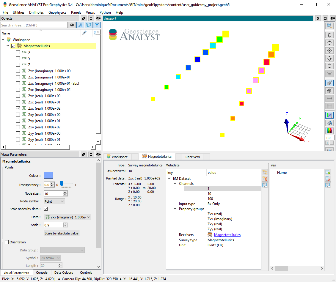
[1]:
import numpy as np
from geoh5py.workspace import Workspace
from geoh5py.objects import MTReceivers

# Create a new project
workspace = Workspace("my_project.geoh5")

# Define a synthetic survey with receivers on 2 lines, 60 m apart
x_loc, y_loc = np.meshgrid(np.linspace(-5, 5, 2), np.linspace(0., 20., 9))
vertices = np.c_[x_loc.ravel(), y_loc.ravel(), np.zeros_like(x_loc).ravel()]

# Create the survey from vertices
mt_survey = MTReceivers.create(workspace, vertices=vertices)
Only receivers are needed to define the survey as MT uses the ambient electromagntic field of the Earth - no transmitters (source) required.
Metadata
Along with the MTReceivers, the metadata contains all the necessary information to define the geophysical experiment.
[2]:
mt_survey.metadata
[2]:
{'EM Dataset': {'Channels': [],
  'Input type': 'Rx only',
  'Property groups': [],
  'Receivers': UUID('90063154-b999-4c13-9a55-ad85e69f688f'),
  'Survey type': 'Magnetotellurics',
  'Unit': 'Hertz (Hz)'}}
Channels
List of frequencies at which the data are provided.
[3]:
mt_survey.channels = [1., 10., 100.]
Input type
Generic label used in the geoh5 standard for all EM survey entities. Restricted to Rx only in the case of natural sources methods.
Property groups
List of PropertyGroups defining the various data components (e.g. Zxx (real), Zxy (imag), …). It is not required to supply all components of the impedence tensor, but it is expected that each component contains a list of data channels of length and in the same order as the Channels (one Data per frequency).
The class method add_components_data can help users add data from nested dictionaries. Below is an example using four components:
[4]:
# Arbitrary data generator using sine functions
data_fun = lambda c, f: (c+1.) * np.sin(f * np.pi * (x_loc * y_loc).ravel() / 200.)

# Create a nested dictionary of component and frequency data.
data = {
    component : {
        f"{component}_{freq}": {"values": (ff+1)*1000. + (cc+1) * 100. + np.arange(vertices.shape[0])} for ff, freq in enumerate(mt_survey.channels)
    } for cc, component in enumerate([
        "Zxx (real)", "Zxx (imaginary)",
        "Zxy (real)", "Zxy (imaginary)",
        "Zyx (real)", "Zyx (imaginary)",
        "Zyy (real)", "Zyy (imaginary)",
    ])
}

mt_survey.add_components_data(data)
[4]:
[<geoh5py.groups.property_group.PropertyGroup at 0x7f30842d4fd0>,
 <geoh5py.groups.property_group.PropertyGroup at 0x7f30841e0d90>,
 <geoh5py.groups.property_group.PropertyGroup at 0x7f30841e14b0>,
 <geoh5py.groups.property_group.PropertyGroup at 0x7f30841e0880>,
 <geoh5py.groups.property_group.PropertyGroup at 0x7f30841e1cc0>,
 <geoh5py.groups.property_group.PropertyGroup at 0x7f30841e2500>,
 <geoh5py.groups.property_group.PropertyGroup at 0x7f30841e2d70>,
 <geoh5py.groups.property_group.PropertyGroup at 0x7f30841e35b0>]
Metadata are updated immediately to reflect the addition of components:
[5]:
mt_survey.metadata
[5]:
{'EM Dataset': {'Channels': [1.0, 10.0, 100.0],
  'Input type': 'Rx only',
  'Property groups': ['Zxx (real)',
   'Zxx (imaginary)',
   'Zxy (real)',
   'Zxy (imaginary)',
   'Zyx (real)',
   'Zyx (imaginary)',
   'Zyy (real)',
   'Zyy (imaginary)'],
  'Receivers': UUID('90063154-b999-4c13-9a55-ad85e69f688f'),
  'Survey type': 'Magnetotellurics',
  'Unit': 'Hertz (Hz)'}}
Data channels associated with each component can be quickly accessed through the BaseEMSurvey.components property:
[6]:
mt_survey.components
[6]:
{'Zxx (real)': [<geoh5py.data.float_data.FloatData at 0x7f30a83b20b0>,
  <geoh5py.data.float_data.FloatData at 0x7f30842d6fe0>,
  <geoh5py.data.float_data.FloatData at 0x7f30842d5030>],
 'Zxx (imaginary)': [<geoh5py.data.float_data.FloatData at 0x7f30a8387010>,
  <geoh5py.data.float_data.FloatData at 0x7f30841e01c0>,
  <geoh5py.data.float_data.FloatData at 0x7f30841e0a60>],
 'Zxy (real)': [<geoh5py.data.float_data.FloatData at 0x7f30841e0130>,
  <geoh5py.data.float_data.FloatData at 0x7f30841e0af0>,
  <geoh5py.data.float_data.FloatData at 0x7f30841e0d00>],
 'Zxy (imaginary)': [<geoh5py.data.float_data.FloatData at 0x7f30841e0a30>,
  <geoh5py.data.float_data.FloatData at 0x7f30841e1540>,
  <geoh5py.data.float_data.FloatData at 0x7f30841e0dc0>],
 'Zyx (real)': [<geoh5py.data.float_data.FloatData at 0x7f30841e1330>,
  <geoh5py.data.float_data.FloatData at 0x7f30841e1720>,
  <geoh5py.data.float_data.FloatData at 0x7f30841e0910>],
 'Zyx (imaginary)': [<geoh5py.data.float_data.FloatData at 0x7f30841e00a0>,
  <geoh5py.data.float_data.FloatData at 0x7f30841e1f60>,
  <geoh5py.data.float_data.FloatData at 0x7f30841e1d50>],
 'Zyy (real)': [<geoh5py.data.float_data.FloatData at 0x7f30841e1b40>,
  <geoh5py.data.float_data.FloatData at 0x7f30841e27d0>,
  <geoh5py.data.float_data.FloatData at 0x7f30841e2590>],
 'Zyy (imaginary)': [<geoh5py.data.float_data.FloatData at 0x7f30841e2380>,
  <geoh5py.data.float_data.FloatData at 0x7f30841e3010>,
  <geoh5py.data.float_data.FloatData at 0x7f30841e2e00>]}
Receivers
Generic label used in the geoh5 standard for EM survey to identify the receiver entity. Restricted to itself in the case of MTReceivers.
Survey type
Label identifier for Magnetotellurics survey type.
Unit
Units for frequency sampling of the data: Hertz (Hz), KiloHertz (kHz), MegaHertz (MHz) or Gigahertz (GHz).